For generations, Black Atlanta has meant more than a place on a map. It has meant the Atlanta University Center, Sweet Auburn, Bankhead, Mechanicsville, Cascade, Collier Heights, Adamsville, West End, Vine City, English Avenue, Grove Park, Pittsburgh, East Lake, Kirkwood, South DeKalb, and the long network of churches, barbershops, block clubs, schools, choirs, family land, and civic memory that made the city feel larger than its borders.
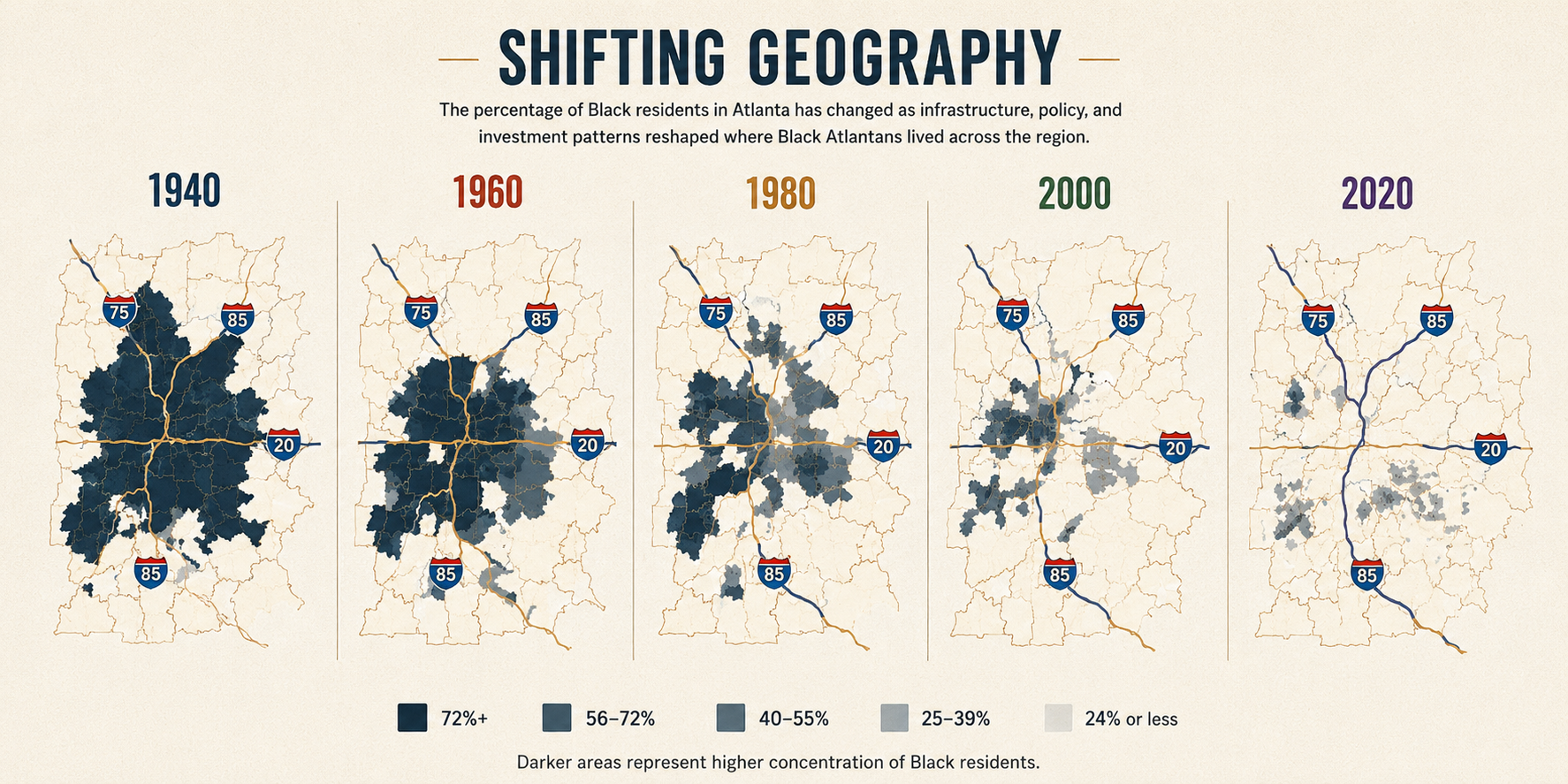
But the map is changing. Since the civil rights era, Black population patterns across Atlanta and Greater Atlanta have moved through a major transformation. The older story centered Black life inside the city. The newer story stretches across South Fulton, South DeKalb, Clayton County, Cobb County, Rockdale County, and beyond.
Black Atlanta did not simply decline. Black Atlanta regionalized.
That does not mean the city stopped mattering. Atlanta remains the symbolic center. It still carries the weight of civil rights memory, Black political power, HBCU culture, gospel, hip hop, neighborhood institutions, and public life. But the population map has widened. The question now is whether the region can grow without erasing the people and places that made Black Atlanta visible in the first place.
The old map: Black Atlanta inside the city
In the middle of the twentieth century, Black Atlantans were heavily concentrated inside the city. That concentration was shaped by segregation, redlining, housing discrimination, school boundaries, employment geography, and the limited places where Black families could safely buy, rent, build, worship, and organize.
The city became a national symbol of Black political power during the 1970s and 1980s. Atlanta was the city of Maynard Jackson, Andrew Young, Coretta Scott King, John Lewis, the Atlanta University Center, Black radio, Black newspapers, and a rising Black professional class. The phrase Black Mecca grew from real institutions, real organizing, and real cultural power.
At the same time, the region around Atlanta was expanding. White flight, new highway access, suburban homebuilding, school district decisions, airport employment, and metropolitan job growth all helped redraw where people lived. Black families also began to seek more space, different schools, ownership opportunities, and suburban versions of stability.
The new map: Black Atlanta becomes metropolitan
The last half century is better understood as a remapping than a disappearance. The City of Atlanta remains central, but Black population and cultural influence now move across a broad regional footprint.
South Fulton is part of that story. So is South DeKalb. So are Clayton communities such as Riverdale, Jonesboro, Forest Park, and Morrow. So are Cobb communities such as Mableton, Austell, Powder Springs, Smyrna, and Marietta. So is Rockdale County, where Conyers and surrounding communities now sit inside the extended Black Atlanta story.
How the CultureUp map reads the regional shift
This table is an editorial guide for readers. A full technical version would require tract-normalized Census work across changing boundaries.
| Geography | What changed | Why it matters |
|---|---|---|
| City of Atlanta | Historic Black neighborhoods remain culturally central while some intown areas face rising costs, redevelopment, and changing racial shares. | The city still holds memory, institutions, and symbolism, even when population patterns shift. |
| Fulton County | The county contains both Atlanta's historic Black core and South Fulton growth, while North Fulton follows a different demographic path. | Fulton shows how one county can hold several Black Atlanta stories at once. |
| DeKalb County | South and east DeKalb became major Black suburban anchors connected to schools, churches, malls, homes, and civic power. | DeKalb helped prove that Black Atlanta was not limited to the city line. |
| Clayton County | Clayton became one of the clearest majority Black suburban transformations in the region. | Its story connects affordability, airport access, working families, and suburban migration. |
| Cobb County | South and west Cobb saw major Black growth in communities that were once outside the usual Black Atlanta narrative. | Cobb complicates the idea that Black Atlanta only moved south or east. |
| Rockdale County | Rockdale reflects eastward and exurban growth tied to housing, affordability, and longer regional movement. | It shows how the Black Atlanta map now reaches farther from the old core. |
Bankhead, West Uptown, Mechanicsville, and the neighborhood question
The regional story can hide what is happening block by block. That is why places like Bankhead and Mechanicsville matter. These neighborhoods are not only demographic units. They are cultural archives.
Bankhead sits inside a westside geography shaped by rail, industry, MARTA access, public investment, disinvestment, redevelopment pressure, and deep Black cultural memory. When newer language such as West Uptown appears around old neighborhoods, residents have a fair question: who is the new name for? Is it a community vision, a marketing label, a development signal, or a bridge between past and future?
Mechanicsville raises another version of the question. It is close to downtown, highways, stadium zones, former public housing sites, and redevelopment corridors. It has long lived near the center of Atlanta without always receiving the full benefit of that proximity. For legacy residents, reinvestment can feel like a promise and a warning at the same time.
Can reinvestment happen without erasure?
Growth is not one story
Population growth does not automatically mean opportunity. Population loss does not automatically mean displacement. The hard work is to ask what sits underneath the numbers.
Some families moved because they wanted more house, more yard, different schools, quieter streets, or the wealth-building path of homeownership. Some moved because rising rent, property taxes, demolition, investor ownership, or redevelopment pressure made staying difficult. Some moved because employment and daily life shifted outward. Some were carried by family networks that made the suburbs feel less like escape and more like continuity.
That is why Black suburban growth should not be flattened into a single explanation. It can represent aspiration, displacement, choice, pressure, wealth building, affordability, exhaustion, or all of those at once.
Public housing, highways, and the policy map
No serious conversation about Black Atlanta's population change can ignore public policy. Highways divided neighborhoods. Urban renewal cleared land. Public housing construction shaped where low income Black families could live. Public housing demolition and voucher relocation reshaped who could remain near downtown. MARTA access changed opportunity in some places while bypassing others. School boundaries and county lines changed the meaning of a home address.
The BeltLine and westside redevelopment added another layer. Investment can bring parks, trails, sidewalks, attention, and amenities. But when land values rise faster than legacy residents can absorb, the benefits of investment often arrive with a bill attached.
What may be driving the trend
The visible trend appears to be driven by overlapping forces: housing affordability, Black suburban aspiration, displacement and redevelopment, public housing policy, airport and logistics employment, school choices, family networks, investor activity, property taxes, and the broader return of higher income residents to intown Atlanta.
In other words, there is no single cause. The story is a braid. Some strands are about opportunity. Some are about pressure. Some are about culture refusing to stay inside old lines.
Who shapes the next map?
The old map of Black Atlanta is no longer enough. The new map is still being drawn.
Bankhead, Mechanicsville, Vine City, English Avenue, Grove Park, West End, South Fulton, South DeKalb, Clayton County, Cobb County, and Rockdale County are all part of the larger story. Some communities are fighting displacement. Some are absorbing growth. Some are becoming new centers of Black political and cultural power. Some are trying to hold onto memory while capital renames the streets around them.
The question is not whether change will happen. The question is whether change will include the people who made these places matter.